- Home /
- Silva Compasses 101
Shop Now
- AMK / SOL
- Ben's / After Bite
- BENCHMADE
- BIOLITE
- BRIDGEDALE
- BUSHNELL
- BUTLER CREEK
- COCOON
- GABEL
- HILLSOUND
- HOPPE'S
- MARKSMAN
- Morakniv
- MSR
- MUELA
- Old Bear
- PACKTOWL
- PLATYPUS
- PRIMOS
- Real Meals
- SEALLINE
- SILVA
- SIMMONS
- SMITH'S
- STANLEY
- TASCO
- THERM-A-REST
- Topo4GPS
- Uncle Mike's
- Wool+Aid
COMPASS 101
Nothing beats a map and compass for reliability. With no batteries to go flat, signal to lose or electronic components to fail, when the chips are down they're the ultimate tool in finding your way.
So - they're super easy to use right? Needle points north - top of the map's north - away we go?! That's a good starting point, but there is a little more to it than that...
When compass and map are used together it’s important to know the local magnetic declination and how to compensate for it. Magnetic declination is the difference between Geographic North/True North (where the map meridians point) and Magnetic North (where the North end of the compass needle points). On mainland New Zealand this variance ranges from 18° in the north to a pretty hefty 26° in the deep south...so an average of around +22° difference between true north and magnetic north. Armed with this bit of knowledge you should now have no trouble orienting your map and setting your course.
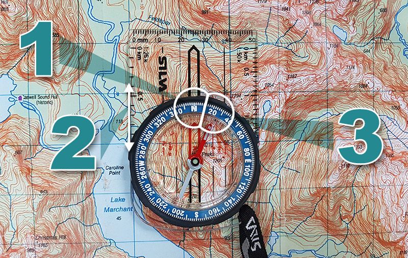
Orienting the map
1) Rotate the capsule of your compass so that the 'N' is facing the front of the baseplate.
2) Line the edge of your compass up with the north/south meridian lines on your map.
3) Now simply rotate the map so that the north tip of the compass needle is pointing at +22° (22° East). Your map is now correctly oriented with your environment. You can easily confirm this by checking some landmarks around you and seeing where they sit on the map.
You can also align a map without a compass using distincitive features such as mountains, rivers, lakes or roads, but the above method is certainly the fastest and most certain option - particularly when visibility is limited.
With your map aligned, you are now ready to plot a course...